PATCO High-Speed Line
From nycsubway.org
![]()
PATCO train at Collingswood. Photo by Bob Vogel, 2005.
Overview
The PATCO line is a compilation of old lines, track connections and new construction. The line includes the never finished Locust Street Subway ending at 9th/10th and Locust Sts. and the Benjamin Franklin Bridge transit line to Camden from 8th and Market. There was once a connection to the Broad/Ridge Spur of the Broad Street Subway between its 8th & Market and Chinatown stations. The Bridge line ended at Broadway Station in downtown Camden (now officially known as the Walter Rand Camden Transportation Center). When the Delaware River Port Authority inherited the line it was decided to extend the line from Camden Broadway first to Ashland (the planned terminal) and then later to Kirkwood (Lindenwold), the current terminal. Expansion plans have included a line to Gloucester and Burlington Counties, and the NJ Route 55 freeway was designed to have transit in the center median. A light rail system is under construction in this part of the state which will provide a transfer to PATCO.
The PATCO line was the first in the United States to use a full ATC system, relying on cab signals. There are no wayside signals except at turnouts. It was also the first to use an automated fare card system.
Maps
Track Map, (PDF) by Michael Brotzman.
Station by Station
Unless noted the line has two tracks and island platforms and full mezzanines underground. The open air stations are different and will be noted for each station.
We will begin at 15th/16th & Locust in Center City Philadelphia and ride east to Lindenwold in New Jersey. This station has been renovated, as have all of the other Philadelphia PATCO stations, but only on the platform level. The mezzanines are of bland construction but clean. The platforms have been tiled and the columns have been covered with yellow and grey melamine panels. Artwork of the area is on the track side walls. The ceiling has transverse metal slats. The station has a full mezzanine which is very bland and boring. The ends of the platform taper. Tracks continue for some distance past the station and are used to store trains. This station now has an elevator for passengers between street and mezzanine and mezzanine to platform.
We board our train and arrive at 12th/13th & Locust, a transfer to the SEPTA Broad Street Subway's Walnut/Locust station. Colors are mauve and cream. Artwork of local attractions are on the side walls. Next up is 9th/10th & Locust, similar to 12/13th, with medium blue and cream tile. This station is closed overnight.
A major transfer hub is next: 8th & Market, a clean station with tile that is white with multi-tone green accents, in a design similar to that on the Broad Street Subway style. Available here is a major shopping hub, The Gallery, and transfers to the SEPTA Regional Rail lines, the SEPTA Market-Frankford Elevated, and the Ridge Spur of the SEPTA Broad Street Subway. The tile colors are red and cream. Elevators are available to the mezzanine and the street. There is a severed connection track here to Broad Street Subway's Broad/Ridge Spur, which is now used as a 6-car layup.
Turning east we enter Franklin Square, currently closed, last having been used during and just after the 1976 American bicentennial celebrations. It was closed for lack of ridership. Departing Franklin Square, We now cross the Benjamin Franklin Bridge into New Jersey. There is a single track on each of the north and south sides of the bridge (carrying westbound and eastbound trains, respectively).
Our first New Jersey station is City Hall (Camden). This station also has been renovated on the platform with tile colors of orange/red and cream. The mezzanine is similar to those on the Broad St. Subway, done in two-tone blue and white tile with mosaic directional signs reading "To Market Street" and "To Arch Street". The station name is also in tile. A closed newsstand was found along with a closed exit to Cooper Street, which is now used as an emergency exit. Conversations with local residents advised that this exit had an extended passageway and was closed due to crime concerns.
Broadway is next, and after seeing the renovated stations is a disappointment since it could be the crown jewel of PATCO. The station has tan colored concrete columns and is in need of touch-up. The west headhouse was renovated and opened as a transfer point from PATCO to the New Jersey Transit RiverLine light rail; the east exit leads to a bus terminal; this area is now referred to as the Walter Rand Transportation Center. There is a concrete sculpture of Camden history over the elevators at the north end. This station is the original terminal of the original Bridge Line, and is the last underground station.
We arrive at Ferry Avenue which has three tracks at the west end with two island platforms, but the center track ends midway into the station and the platforms form one island platform at the eastern end. The center track was used for Ferry Avenue locals which are no longer being run. The track here is full tie and ballast.
The open air stations have two glass block exits on the platform level which meet in a common fare control area at street level unless noted otherwise. Sign color is red on white background. The fare control areas at street level have windows but are otherwise visually boring.
Collingswood is next and is located on a concrete viaduct. The rails on the viaduct are on small pads with no trough. The viaduct is unusual in the lack of side rails; the third rails are located near the outer edge.
Westmont follows and is similar to Collingswood. An interesting feature here is the appearance of NJT's Atlantic City Line, to the north of and below our line. After this station, the line changes to embankment and surface before descending to open cut.
Haddonfield is next, the only station in an open cut. According to local residents it was built this way due to Haddonfield's objections to an elevated structure. Platform design is similar to the other stations except that the exit leads up to the street. At this station the NJT track is to our north.
Leaving Haddonfield, the line again rises to an embankment before entering the newest station in the system, Woodcrest. This stop has three tracks and two island platforms; the center track is used for some peak direction service. Exit is down via stairs and elevator. Signs include braille and raised letter. Woodcrest was built 12 years after the line first opened.
Ashland is next, and was supposed to be the original end of the line. This station is like Collingswood and is on an embankment.
Lindenwold is next and last, and is the most heavily used station of the entire line. The highlight here is the PATCO shops and yard to the north and east of the station. Elevators are present. This station is very light and airy--easily the jewel of the system.
Before the former track connection to the SEPTA Broad Street Subway was severed, PATCO bridge line cars used Fern Rock Yard for storage and maintenance.
Roster
| Numbers | Type | Manufacturer | Year Built | Status | Notes |
|---|---|---|---|---|---|
| 101-125 | PATCO I | Budd | 1968 | In service | |
| 201-250 | PATCO I | Budd | 1968 | In service | |
| 251-296 | PATCO II | Vickers Canada | 1980 | In service |
The trains are OPTO with the operator on the left and an
extra view window on the right. The cab has only a knee-high door
separating operator from passengers, allowing a great view of the
controls before the operator draws a dark curtain and begins the trip.
The trains have no anti climbers on the #1 end and very small anti-
climbers on the #2 end. Cars are 67' 6" long, stainless steel. Cars
101-125 are single cars; 201-250 are paired cars, 251-296 are paired
cars, built by Vickers Canada under license from Budd. Half the seats
in each car face the direction of travel.
The destination signs have six destination readings with the proper one lit by fluorescent lighting--the others being behind black glass. The signs read as follows:
| PHILADELPHIA LOCAL | PHILADELPHIA EXPRESS |
| LINDENWOLD LOCAL | LINDENWOLD EXPRESS |
| FERRY AVENUE LOCAL | WOODCREST LOCAL |
Photo Gallery
| Five Random Images | ||||
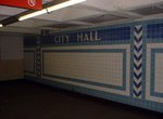 Image 16787 (38k, 640x480) Photo by: Peggy Darlington Location: City Hall |  Image 49650 (90k, 920x618) Photo by: Harv Kahn Location: Ferry Avenue | 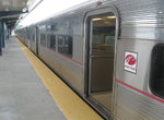 Image 100687 (230k, 1024x768) Photo by: Andre Samuel Location: Lindenwold |  Image 100688 (178k, 1024x768) Photo by: Andre Samuel Location: Lindenwold |  Image 159526 (264k, 1220x783) Photo by: Lee Winson Location: Broadway |
Photos By Location
Photo locations: 15th/16th & Locust, 12th/13th & Locust, 9th/10th & Locust, 8th & Market, Franklin Square, Ben Franklin Bridge, City Hall, Mickle Street Tunnel Portal, Broadway, Between Broadway & Ferry Ave., Ferry Avenue, Collingswood, Westmont, Haddonfield, Woodcrest, Ashland, Lindenwold, Lindenwold Shops, Lindenwold Yard, Fern Rock Yard, (Misc/Unknown)
Page Credits
By Peggy Darlington. Track Map by Michael Brotzman.
Links
SEPTA Broad Street Subway • SEPTA Market-Frankford Elevated • SEPTA Regional Rail • SEPTA Rt. 100: Norristown Line • SEPTA Rt. 101/102: Media-Sharon Hill Line • SEPTA Subway-Surface Streetcar Lines • PATCO High-Speed Line