New Orleans, Louisiana
From nycsubway.org
Overview
New Orleans is a very unique city bustling with history. It is no surprise that this rolls over to their streetcar system. New Orleans' residents are very particular in that they are called streetcars, and not trolleys. A "trolley" is technically a mechanism that transmits electric current to the motors. New Orleans had their streetcars for over 60 years before a trolley device was used to power them, and was in fact the first city west of the Allegheny Mountains to begin passenger rail service.
By the 1920's, New Orleans had over 200 miles of streetcar trackage criss-crossing through the city. Eventually, almost all of that trackage was abandoned and ripped up in favor of more "modern" buses. By the 1950's, all that was left of this vast system was the Desire Streetcar Line, the Canal Street Line, and the St. Charles Line. The Desire route shut down in the 1950's and in the mid 1960's New Orleans lost the Canal Street route, leaving the St. Charles Line all by itself. Thankfully, that sad story has changed, and continues to change as new lines open, and others are being planned.
The streetcars are run by the RTA, the Regional Transit Authority, which also runs the buses in New Orleans. The one way fare is $1.50, allowing one transfer. A day pass could be bought for $5.00, or a 3-day pass for $12.00. These day or 3-day passes are good for unlimited use on all the streetcars or buses.
The future of streetcars in New Orleans is bright. In addition to all the additions to the system over the last decade, there is another route planned. There may one day be a "Streetcar Named Desire" once again, as the RTA is planning a restoration of about 3 miles of the former Desire Corridor route. The proposed line would run from Canal Street to Poland Avenue using N. Rampart St. and St. Claude Ave. The line would loop back (similar to the St. Charles Line at Canal) in a loop formed by Canal, Basin, Toulouse, and N. Rampart Streets. The stations are proposed to be ground level center island platforms, many with canopies.
The project has been widely accepted, and NIMBY objections are minimal, with a few concerns that were worked out. The biggest obstacle at this point seems to between the RTA and the Norfolk Southern Railway. The Desire Streetcar line would have to cross the NS right of way at grade near St. Claude Ave. and Press St. The RTA proposed elaborate lights and gates along with other solutions, but the railroad has refused any plan that does not entail complete grade separation. An underpass was ruled out by the RTA because of the flooding nature of New Orleans, and residents refuse to accept an overpass as they feel it would destroy the historic feel of the neighborhood. The Desire Corridor route may be scrapped if a concession can not be worked out between NS and the RTA, or the line will have to terminate at the NS tracks, well short of the planned terminal. It will be interesting to see how they will solve this final snag in this otherwise completed proposal. Other than that, streetcars flourish once again in New Orleans, and will for many years to
come.
Aftermath of Hurricane Katrina
On August 29, 2005, the worst hurricane in New Orleans history smashed into town. Hurricane Katrina wreaked havoc on the Crescent City, with 140mph winds and monsoon rains, crumbling levees and putting entire neighborhoods under five feet of water. Hundreds of houses and businesses were destroyed or heavily damaged. The streetcar system suffered badly, with floodwaters inundating the new A. Philip Randolph Maintenance Facility and rendering the new Van Dullen fleet of Canal cars and six of the seven Riverfront trolleys inoperable. The new trackway, however, was virtually untouched. Over on the St. Charles line, Carrollton Station escaped flooding and damage, as did the 35 vintage 1924 Perley Thomas streetcars, but the line itself was knocked out by falling trees, light poles and overhead wires and cables. Much of the bus fleet was also rendered useless by the flooding. RTA lost hundreds of its employees to forced evacuation. Gradually, RTA personnel returned, enabling some buses to resume limited service.
In December, RTA streetcar personnel towed St. Charles car 930 over to Canal Street for a test of the car on the intact tracks of Canal Street and Riverfront. The test was a success, and 8 cars were on hand for startup of limited service on December 18, 2005. Service runs daily between 6:30am and 10:00pm. By April, all of Canal Street may reopen for service with more St. Charles cars moved over. Meanwhile, work has begun to rebuild St. Charles; however, service is not expected to return until Fall 2007. In addition, a Canal car and a Riverfront trolley have been moved to Brookville Equipment for evaluation of the work needed to get the Canal/Riverfront fleets back in service; estimates are running about $1 million per car.
Restoration of streetcar service is considered a major element in the rebuilding of New Orleans. As stated already, the goal to restoring the Crescent City toward better health consisted of rebuilding homes, neighborhoods and transit. Resuming service on lower Canal and on Riverfront was a small but significant step. Because the von Dullen and Riverfront fleets were sidelined, New Orleans had to get an FTA waiver to use the non-ADA-compliant 1924 cars to return lines to service. As long as NORTA ran duplicative accessible bus service, the FTA granted the waiver. (Of course, that didn't apply to St. Charles, since that line was "grandfathered".)
Randolph (Canal) Station had dried out enough to allow for streetcar operations to be based there while the newer cars were brought to Carrollton Shops to begin rehabilitation. With the help of a portable substation loaned from Boston's MBTA, the RTA was able to return streetcars to the full length of the new Canal/Cemeteries and Canal/City Park lines on April 2, 2006. Still, service was quite limited, with the Perley Thomas cars operating every 20 minutes or so during the daytime. Later, service was increased to every 15 minutes (12 at rush hours). In addition, car 461, the only surviving Riverfront car, was returned to service in a new blue livery.
Meanwhile, work began on restoring service to the historic St. Charles line. First, the downed trees and the fallen wires had to be removed, and new wire strung. In addition. new substations and feeder cables had to be constructed. This project tooK more than two years to complete. The first step was to restore service to the in- town portion between Canal Street and Lee Circle, which occurred on December 19, 2006. Enough work had been performed by November 11, 2007 to extend service through the Garden District as far as Napoleon. Further extension to Uptown, passing Audubon Park and Loyola and Tulane Universities, occurred a month later, on December 23, 2007. The last segment, Carrollton Avenue, reopened for service on June 22, 2008.
Service on St. Charles during the daytime is near pre-Katrina levels; however, night service has been cut back to infrequent and erratic levels. However, another small improvement came about when RTA extended service on both Canal and St. Charles to after 1:00 am.
Meanwhile, Brookville Equipment, which supplied the trucks and some other components for the Von Dullen cars, was brought in to help restore that fleet. Car 2008 will be the first of the new cars to return to service, probably in September 2008. The others will return at the rate of one or two a month, and sometime in 2008, the last Perleys will again operate on Canal--a line that was abandoned in 1964, and where it was never again expected to see them in this territory again!
Route Map

The Lines
St. Charles Line
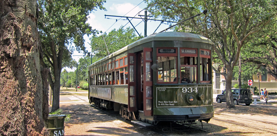
The St. Charles Streetcar route is the oldest continuously operating streetcar in the entire world! The vintage 1924 streetcars currently in service on the route modestly take this honor in stride as they rumble along their route with their distinctive pudda-pudda-pudda-pudda air compressor sound. Streetcars have been rolling down St. Charles Avenue and Carrollton Ave. along this route for over 150 years. They of course have become very popular with the tourists, but they also nonetheless provide reliable transportation daily to residents traveling between the Garden District and the Central Business District of New Orleans, the same reason they were implemented there in the mid 19th century.
The St. Charles line is a 13 mile journey through history, passing in front of historic mansions and plantation homes in the Garden District, while riding vintage streetcars built in 1924 by Perley Thomas. These vintage units are in the 900 series, and green in color. The line begins at the intersection of Claiborne and Carrollton Avenues where the tracks just end in a stub at Claiborne Avenue. They travel on the "neutral ground" in the center of Carrollton Avenue towards the Mississippi River. ("Neutral ground" is what New Orleanians call a median, basically a large grassy landscaped area down the middle of many roads in New Orleans). The Carrollton Shop is also off of the route as it runs along Carrollton Ave. This is the shop that services the streetcars, and built the replica streetcars for New Orleans' other routes.
At the intersection of Carrollton and St. Charles Avenues, the line bends onto St. Charles Avenue for a ride past old historic mansions under a tunnel formed by seemingly as old trees. At Lee Circle the streetcar route shares a single track with opposing streetcar traffic for a brief moment as it swings around the circle, and then onto the neutral ground of Howard Street. Then, the streetcar enters Carondelet Street for the final leg of the journey to the Central Business District. Once on Carondelet Street, the streetcars share the road with regular vehicular traffic. Then at the intersection of Carondelet and Canal Street, the streetcar loops around onto Canal Street for one block and then back onto St Charles Avenue for its return trip to the Garden District. The stations consist of modest uncovered ground level concrete areas to the sides of the tracks.
Photo locations: Canal/Carondelet, Canal St. Terminal (Between Carondelet & St. Charles), Canal/St. Charles, St. Charles bet. Canal & Common), St. Charles/Common, St. Charles/Gravier, St. Charles/Union, St. Charles/Perdido, St. Charles/Poydras, St. Charles/N. Maestri, St. Charles/Lafayette Square, St. Charles/Girod, St. Charles/Julia, St. Charles/St. Joseph, Carondelet/Howard, Carondelet/St. Joseph, Carondelet/Julia, Carondelet/Girod, Carondelet/Lafayette, Carondelet/Poydras, Carondelet/Perdido, Carondelet/Union, Carondelet/Gravier, Carondelet/Common, Lee Circle, St. Charles/Ponchartrain Expy., St. Charles/Clio, St. Charles/Erato, St. Charles/Thalia, St. Charles/MLK Blvd (aka Melpomene), St. Charles/Terpsichore, St. Charles/Euterpe, St. Charles/Polymnia, St. Charles/Felicity, St. Charles/St. Mary, St. Charles/St. Andrew, St. Charles/Josephine, St. Charles/Jackson, St. Charles/Philip, St. Charles/First, St. Charles/Second, St. Charles/Third, St. Charles/Fourth, St. Charles/Washington, St. Charles/Conery, St. Charles/Sixth, St. Charles/Seventh, St. Charles/Eighth, St. Charles/Harmony, St. Charles/Toledano, St. Charles/Louisiana, St. Charles/Delachaise, St. Charles/Aline, St. Charles/Foucher, St. Charles/Antonine, St. Charles/Amelia, St. Charles/Peniston, St. Charles/General Taylor, St. Charles/Constantinople, St. Charles/Marengo, St. Charles/Palm Terr., St. Charles/Milan, St. Charles/General Pershing, St. Charles/Napoleon, St. Charles/Jena, St. Charles/Cadiz, St. Charles/Valence, St. Charles/Bordeaux, St. Charles/Upperline, St. Charles/Robert, St. Charles/Soniat, St. Charles/Dufossat, St. Charles/Valmont, St. Charles/Leontine, St. Charles/Jefferson, St. Charles/Octavia, St. Charles/Joseph, St. Charles/Arabella, St. Charles/Nashville, St. Charles/Rosa Parks, St. Charles/Eleonore, St. Charles/State, St. Charles/Webster, St. Charles/Palmer, St. Charles/Henry Clay, St. Charles/Calhoun, St. Charles/Exposition, St. Charles/Audubon Park, St. Charles/Audubon Place, St. Charles/Walnut, St. Charles/Newcomb, St. Charles/Audubon, St. Charles/Broadway, St. Charles/Pine, St. Charles/Lowerline, St. Charles/Millaudon, St. Charles/Cherokee, St. Charles/Hillary, St. Charles/Adams, St. Charles/Burdette, St. Charles/Fern, St. Charles/Huso, St. Charles/Short, Riverbend (St. Charles & Carrollton), Carrollton/Hampson, Carrollton/Maple, Carrollton/Burthe, Carrollton/Freret, Carrollton/Zimpel, Carrollton/Oak, Carrollton/Plum, Carrollton/Willow, Carrollton/Jeannette, Carrollton/Birch, Carrollton/Green, Carrollton/Hickory, Carrollton/Cohn, Carrollton/Spruce, Carrollton/Panola, Carrollton/Sycamore, Carrollton/Neron, Carrollton/Claiborne, Carrollton Station (Shops)
| Five Random Images | ||||
 Image 29941 (202k, 720x478) Photo by: Peter Ehrlich Location: St. Charles/St. Andrew | 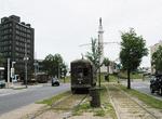 Image 29943 (144k, 720x478) Photo by: Peter Ehrlich Location: Carondelet/Howard |  Image 89520 (242k, 864x544) Photo by: Peter Ehrlich Location: St. Charles/Foucher |  Image 89530 (229k, 864x574) Photo by: Peter Ehrlich Location: St. Charles/Marengo |  Image 89633 (241k, 864x555) Photo by: Peter Ehrlich Location: St. Charles/Antonine |
Riverfront Line
In the summer of 1988 the lonely St. Charles Line got some company again when the first new streetcar route in New Orleans since the mid 1920's opened for service. Unlike the St. Charles line, the new Riverfront line is more of a tourist route running along the Mississippi River, connecting the Convention Center and Riverwalk shopping area to the French Quarter and ending at Esplanade Ave. (French Market). The Riverfront line runs entirely in its own right of way, and its stations consist of ground level island platforms with canopies between the tracks.
The rolling stock for the line, in the 400 series, consists basically of built-from-scratch replicas of the vintage Perley Thomas streetcars running on the St. Charles Route, but painted red instead. In 1996, the Carrollton shops built a prototype streetcar for the Riverfront line, using the shell of Perley Thomas car #957, which became #457. #458 was also built by the Carrollton shops using parts from PCC cars retired from SEPTA in Philadelphia. The remaining few streetcars for the line were built completely from scratch in the RTA shop, made to look old, and used PCC-like running gear from the Czech firm Tatra. (A modern unit was on loan for a while in New Orleans from the Czech Republic running on the Riverfront and St. Charles lines in the late 1990's and early 2000's, seen in some of the photos below). The Riverfront replica streetcar units are ADA equipped, unlike their vintage cousins on the St. Charles Line. The Riverfront units also lack the distinctive sound of the air compressors and gear noise that their older cousins have.
The Riverfront Line is a relatively short route, but became very popular, thus sparking the planning, and finally the reintroduction of streetcars to the old Canal Street Route.
Photo locations: Riverfront/Esplanade - French Market, Riverfront/Ursulines, Riverfront/Dumaine, Riverfront/Jackson Square, Riverfront/St. Peter, Riverfront/Toulouse, Riverfront/Conti, Riverfront/Bienville, Canal Station/Canal Junction, Foot of Canal St., Riverfront/W. Of Canal, Riverfront/Canal, Riverfront/Poydras, Riverfront/Julia
| Five Random Images | ||||
 Image 29776 (148k, 720x478) Photo by: Peter Ehrlich Location: Riverfront/Conti |  Image 29904 (147k, 720x478) Photo by: Peter Ehrlich Location: Riverfront/Jackson Square | 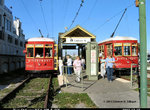 Image 50398 (239k, 1024x795) Photo by: Herman R. Silbiger Location: Riverfront/Toulouse |  Image 89515 (152k, 864x553) Photo by: Peter Ehrlich Location: Riverfront/Dumaine |  Image 109807 (200k, 1044x701) Photo by: Richard Panse Location: Riverfront/Poydras |
Canal Street Line
With the great success of the Riverfront route, New Orleans decided to rebuild its Canal Street streetcar route. The line replaces the Route 42 bus that had been running on the neutral ground of Canal Street since the 1960's when the streetcars were retired due to so-called modernization, replaced with air conditioned buses. Canal Street is New Orleans' "Main Street". After much planning, and rebuilding, on Oct 2, 2003, a streetcar returned to Canal Street for the first time in almost 40 years, as unit #2017 cautiously progressed towards the Cemeteries for a test run. Revenue operation is to begin in Spring 2004 after a few months of testing and finishing touches.
The route begins at Esplanade, and runs with the Riverfront Line to Canal Street where it turns to the neutral ground for the entire length of Canal St. for its journey of about 3 miles, ending at City Park Avenue at the cemeteries. There is also a 1 mile streetcar spur off of the Canal Street route that connects the Canal Street route to Beauregard Circle at City Park, and runs along the neutral ground of N. Carrollton Avenue for its 1 mile run.
The rolling stock for the Canal St. line, in the 2000 series, consists of streetcars built by the RTA themselves, and are also replicas to the 1924 Perley Thomas units. For the new units, they wanted to preserve the roofline and vintage look of the 900 series units, make them ADA compliant, and include air-conditioning. Unlike the tourist Riverfront route, the Canal St. route is mainly a commuter line, and it would have been a hard-sell if they were going to replace air-conditioned buses and with hot and sweaty "vintage" streetcars. The RTA built and tested prototype unit #2001 to meet these challenges. The test unit was successful and its sisters 2002 to 2024 were built entirely from scratch at the RTA's own Carrollton shop.
The stations consist of ground level concrete side platforms, some with bus shed-like structures. The entire line is in the neutral ground of Canal Street, which is concrete east of Interstate 10, and grass west of Interstate 10. The N. Carrollton spur is in the grassy neutral ground of that street.
In New Orleans, any major event is another reason to party. About 200 people gathered at Canal and Salcedo Streets at 3:10am on April 18, 2004 for the party thrown for the first Canal Streetcar in nearly 40 years--waiting for the first car to pull out from the new A. Philip Randolph Station. Coffee and beignets were served--another New Orleans tradition.
Photo locations: Canal Station/Canal Junction, Canal/Iberville/Poydras/Wells, Canal Terminal, Canal/Peters/Tchoupitoulas, Canal/Magazine/Decatur, Canal/Chartres/Camp, Canal/Exchange, Canal/St. Charles/Royal, Canal/Carondelet/Bourbon, Canal/Dauphine/Baronne, Canal/Burgundy/University, Canal/Rampart, Canal/Basin/Elk, Canal/Saratoga, Canal/Liberty/Treme, Canal/LaSalle/Marais, Canal/Villere, Canal/Robertson, Canal/Claiborne, Canal/Derbigny, Canal/Roman, Canal/Prieur, Canal/Johnson, Canal/Galvez, Canal/Miro, Canal/Tonti, Canal/Rocheblave, Canal/Dorgenois, Canal/Broad, Canal/White, Canal/Dupre, Canal/Gayoso, Canal/Salcedo, Canal/Lopez, Canal/Rendon, Canal/Jefferson Davis Pky, Canal/Clark, Canal/Genois, Canal/Telemachus, Canal/Cortez, Canal/Scott, Canal/Pierce, Canal/Carrollton, Canal/David, Canal/Solomon, Canal/Hennessey, Canal/Alexander, Canal/Murat, Canal/Olympia, Canal/St. Patrick, Canal/Bernadette, Canal/Anthony, Canal/City Park (Cemeteries Terminal), North Carrollton/Iberville, North Carrollton/Bienville, North Carrollton/Conti, North Carrollton/St. Louis, North Carrollton/Toulouse, North Carrollton/St. Peter, North Carrollton/Orleans, North Carrollton/Dumaine, North Carrollton/Sherwood Forest, North Carrollton/Delgado, North Carrollton/City Park, North Carrolton/Esplanade (Museum Terminal), Canal Street Station (Yard)
| Five Random Images | ||||
 Image 29764 (220k, 720x470) Photo by: Peter Ehrlich Location: North Carrollton/Dumaine |  Image 29907 (208k, 720x457) Photo by: Peter Ehrlich Location: Canal/St. Charles/Royal | 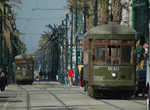 Image 46685 (212k, 864x574) Photo by: Peter Ehrlich Location: Canal/Peters/Tchoupitoulas | 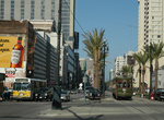 Image 46696 (222k, 864x574) Photo by: Peter Ehrlich Location: Canal/Peters/Tchoupitoulas |  Image 109895 (225k, 1044x701) Photo by: Richard Panse Location: Canal/Basin/Elk |
Rampart-St. Claude Line
Phase I of the Rampart–St. Claude Line opened on January 28, 2013, operating from Union Terminal along Loyola Avenue to Canal Street. Streetcars continued down Canal Street to either Harrah's on Canal Street or French Market on the Riverfront Line, until the Rampart-St. Claude portion was completed. The line in its current form (from Union Terminal to Elysian Fields Avenue) began operating on October 2, 2016. For the most part, the streetcar tracks run along the innermost traffic lane of the streets it operates along, rather than on a "neutral ground" found on the St. Charles and Canal Street lines. The line is operated with the 2000 series of red trams found on the Canal Street line. Frequency is a rather depressing 20 minutes throughout the day, operating approximately 6 am to midnight.
Photo locations: Union Terminal, Julia Street, Hyatt Regency, Poydras Street, Canal Street, Conti Street, St. Ann Street, Ursulines Street, Esplanade Avenue, Pauger Street, Elysian Fields Avenue
| Five Random Images | ||||
 Image 158146 (850k, 1220x820) Photo by: David Pirmann Location: Elysian Fields Avenue |  Image 158147 (435k, 1220x820) Photo by: David Pirmann Location: Elysian Fields Avenue | |||
Roster
| Designation | Year | Line | Numbers |
|---|---|---|---|
| NOPSI Perley Thomas | 1924 | St. Charles | 900, 903, 904, 905, 906, 907, 910, 911, 914, 915, 920, 921, 922, 923, 926, 930, 932, 933, 934, 937, 940, 945, 947, 948, 951, 953, 954, 961, 962, 963, 965, 968, 969, 971, 972 |
| NOPSI Perley Thomas | 1924 | Riverfront | 450 (ex-924), 451 (ex-919), 457 (ex-957) |
| RTA Perley Thomas Replica | 1998 | Riverfront | 458-463 |
| RTA Perley Thomas Replica Prototype | 1999 | Canal St./Rampart | 2001 |
| RTA Perley Thomas Replica | 2002-2003 | Canal St./Rampart | 2002-2024 |
Other surviving Perley Thomas cars are located at: Pennsylvania Trolley Museum (832), Connecticut Trolley Museum (836), Shore Line Trolley Museum (850), North Carolina Transportation Museum (912), San Francisco Municipal Railway/F-Market Line (two cars: 913, formerly owned by Orange Empire Railway Museum and sold to MUNI in 2005; and 952, leased from NORTA), "Chattanooga Choo Choo" (959), Lowell Historical Park, Lowell, MA (966).
Former Riverfront Melbourne W2 cars 452 (ex-626), 454 (ex-478), and 455 (ex-331) were sold to Memphis MATA in 1998. NOPSI Perley Thomas 456 (ex-952), used on the Riverfront Line, to San Francisco MUNI.
Page Credits
By Chris Sattler and Peter Ehrlich.